Chapter---13
of our Mughal Road Motor Biking Escapade
Chapter—13
of (15)

Our
today’s route will pass through Kokernag—--Deval Gam-----Vailoo-----Daruloom-----Daksum—--SinthanTop-----Singhpura-----Dichar-----Chatroo
Nullaha-----Bandar-Koot-----Dul-----Sheikhpora-----Chowgam-----Kishtwar-town-----
Drabshalla-----Thatri-----Premnagar-----Ghuraka-----Mandelah-----Paka-Pul-----New
Doda town.
The
distance from Kokernag to Doda town that we would be travelling today is about 220
Km. But the road is narrow, rugged, and dangerously uneven with sharp bends and
blind turns that is full of dangerous landslides and small rivulets crossing.
So today we may take 8 to 9 hours of travelling. Because wherever we may like
the scenic beauty of nature or other natural places of attracting views, we may
stop to enjoy, relax and click pictures. We just want to enjoy our this adventurous
and exciting motor biking trip rather than rushing like an impatient traveller.
Our
today’s proposed Night halt is at Doda town’s government guest house.
On
30th of August 2012, after our morning breakfast at Kokernag, we filled our motor bikes fuel tanks to full
capacity, knowing it well that there won’t be any petrol bunk available on the
way, untill we reach Kisthwar town which is about 140 Km away. Then we drove
our motor bikes towards Sinthan Pass that connects Kashmir valley with Jammu
region. As we drove past the Kokernag Gardens, after many small hamlets, the
first popular village that comes on the way is Daksum.


Daksum
is located at an altitude of 2,438mt (8,500 ft) above the sea level. It is situated
at a distance of 40 km from the main district headquarters that is Anatnag
and about 85 km from Srinagar and is about 15 Km from Kokernag. It is on
the trekking route from Kokernag to Kishtwar. From here many trekking trails
lead to Kisthwar through Sinthan Top.
The
picturesque Daksum is situated amidst the magnificent grandeur of the springs;
it presents an awe-inspiring awesome sight. Daksum offers peace and tranquillity. The only sound heard there is that of cascading Bringhi River,
rushing right through its centre. Daksum is a place where you can revel in
solitude and be one with nature. Pine trees; green meadows, clear gurgling
brooks, fresh mountain air all promise to make your experience invigorating and
long lasting.
Daksum in Kashmir valley is a must for those
who are fond of treks and nature.


A
walk in Daksum will take you up to the hills enveloped in lush coniferous trees
and past gurgling brooks. The simple music coming out of the flute of an unseen
shepherd tending to his flock will keep you mesmerized. The landscape of Daksum
is quite serene. From the tree-covered hills, you will suddenly find yourself
in grassy meadows serving as host to the pasture grazing herds of sheep. The
invigorating mountain air, the calm and serenity, the densely clad hills, all
make the trip to Daksum a memorable experience. Then, there are the snow-capped
mountains in the background that further enhance the beauty of this place. Daksum
is also famous for its trout - an angler's heaven.
From
Duksum onwards the gradient of the road is a very steep climb and at certain
stretches the road is bad, full of landslides and small rivulet those are
crossing the road and at certain stretches the sides of the road were
covered with thick, hard snow. So we had
to practically drive very carefully otherwise we may have had invariably met
with serious accidents.


These
are the pictures of Birch Trees. In olden days the barks of which were used for
writing literature. Pictures clicked @ Sinthan Pass by ASHOK PARIMOO
These
are the pictures of Birch Trees. In olden days the barks of which were used for
writing literature.are the pictures of Birch Trees. In olden days the barks of which were used for
writing literature.
Just
few km before Sinthan Top, at a height of nearly above 10,000 feet a whole
stretch of white barked fir trees starts. In olden days the barks of these
trees were used as fine, smooth, thin sheets to write scripts of written
literature. And these barks would lasts for centuries without getting frayed or
spoilt. Even today we in India have thousands of such written documents to
prove its authenticity.
Sinthan
Pass, also called as Sinthan Top


The Sinthan Top, at 12,450 ft., is one of the barren passes of Pir Panjal. The top portion of this Sinthan top is completely bald without any dense forests of Deodar, pine or fir trees. It’s just a plateau. Once we reached on the top portion of the Sinthan top, it felt as if we were on top of the world with plenty of fresh pollution free air and cold breeze and it felt as if the aquamarine blue sky was just at a height of our arms length. At this height we could really touch the sailing clouds. To inspire our thrilling excitement of achieving one of the most thrilling experience of riding through one of the most difficult strenuous terrene road.


At top of the Sinthan Top there is a huge high rectangular steel structure which reads as “WELCOME TO
SINTHAN TOP” and shows the road distances of few nearby towns. This high steel
structure is erected by Boarder Road Organization who constantly manages the
whole stretch of road.


The Sinthan Top, at 12,450 ft., is one of the barren passes of Pir Panjal. The top portion of this Sinthan top is completely bald without any dense forests of Deodar, pine or fir trees. It’s just a plateau. Once we reached on the top portion of the Sinthan top, it felt as if we were on top of the world with plenty of fresh pollution free air and cold breeze and it felt as if the aquamarine blue sky was just at a height of our arms length. At this height we could really touch the sailing clouds. To inspire our thrilling excitement of achieving one of the most thrilling experience of riding through one of the most difficult strenuous terrene road.
After
Sinthan Top, to drive towards Kishtwar the road starts descending at steep
gradient. The road is fairly ok except at certain stretches. On the way till Kishtwar
town we have to pass through many small hamlets and villages. All along the
stretch the population is very thinly inhabited. Wherever and whenever we came
across any small village, near these villages on either side of the road there
are small water-mills, those in local language are called “Chakkies”. These
“Chakkies are olden days milling machines which are operated with the force of
water and are used for grinding, wheat, spices, corn, chillies etc.
On
the way to Kishtwar we have to cross Chenab River twice. Once at Chatroo
Nullaha and then at Chowgam. And after that all along our journey from Doda
till Batote our road is all along parallel to Chenab River. All along the road the
drive is dangerous and scary. Any small or big mistake while driving is sure
invitation to fatal death.
From
Chowgam there is a road which goes towards Keylong---Tandi (which is on the way
to Leh from Rohtang Pass, in Himachal Pradesh) and this road is called as
Keylong--Tandi--Kisthwar road.
Now
under construction is the Kishtwar-Anantnag tunnel that will pass through the
Sinthan Pass.
The
ambitious project to bore a tunnel between Vailoo in South Kashmir and
Singhpora in Kishtwar, once completed, will revolutionise road connectivity
between the Kashmir Valley and the Doda region of Jammu.
Even
as work continues on the road which goes through one of the highest passes in
the Himalayan region (Sinthan Top) that will connect Kishtwar, (the remote
district in the Doda region), with Anantnag in South Kashmir. The tunnel will
shorten the travelling distance from eight hours to two hours.
The
five-km-long tunnel is financed by the Jammu and Kashmir Bank on a
public-private-partnership basis. International bids have been invited to take
up the work.
Recently
a technical team of consultants from Mumbai visited the area to conduct an
informal survey for making the departmental Project Report (DPR). They trekked 13 km to see how the work
can be made possible.
The
team was accompanied by Minister for Roads and Buildings G.M. Saroori, who has
been pivotal in pushing the project through. He later told The Hindu that
the tunnel will be completed in two years, after the bidding is finalised, at a
cost of Rs.640 crore.
Under
the Prime Minister's Reconstruction Plan, Rs.640 crore has already been
earmarked for the road that will pass through Sinthan Pass.
Work
on the project was stopped in 2008 when militants killed four General Reserve
Engineering Force (GREF) personnel, including a Lieutenant Colonel, on June 13
that year.
While
the BRO proposed a six-km-long tunnel between Pahalgarh and Alan Gadole, the
State government prefers a four-km-long tunnel from Singhpora and Vailoo.
The
work is almost complete on the Anantnag side but only light vehicles from South
Kashmir to Kishtwar ply on a daily basis. The Pass closes soon after the first
snowfall until April.
A traveller has to cover 290 km to reach Kishtwar via the Srinagar-Jammu highway,
and the Srinagar-Sinthan-Kishtwar road reduces the distance by 200 km.
Earthwork and two-laning have been completed from Batote to Chatroo on the
Kishtwar side, but the middle stretch needs a lot more work.
Kishtwar
Town
Pictures of Present Day Kishtwar Town


Kishtwar
is first referred to in the Rajatarangini by the ancient name Kashthavata,
during the reign of Raja Kalsa of Kashmir (1063–1089), when
"Uttamaraja", the ruler of Kashthavata visited the court of the
Kashmir King in company with several other hill chiefs to pay their respects to
the Raja. The Mehta Family was given the lands of Kishtwar by the King of Kashmir.
Their family temple "Hatta Wali Mata" and their heritage
can still be tracked back to Kishtwar. The founder of this family was the
Commander-in-Chief of the Kashmir Army "Sip-E-Salar Sri Jiya Lal
Mehta". Known for his bravery and velour he fought the Mughals and
northern raiders who invaded the land.
The
current name, Kishtwar, is a combination of the earlier name Kishaswar and
"Kishat Rishi", who stayed there.
The
main language spoken here is called Kishtwari (related to Kashmiri language) by
locals.
Attractions
The
Chenab River flows through the district and is the site of the
hydroelectric power projects of Dul Hasti 780 MW, Ratle 480 MW, Kirthai 1400
MW, Pakal Dool 700 MW, Lower Kalnai 200 MW and Chaudhary 150 MW with the
highest per capita wattage production in world for such a small area. Kashmir
sapphire was mined at Padder valley. And gypsum is mined at Trigam. The famous
Sinthan and Margan tops are high motorable road passes. The Steep Brahma
mountain peak is situated at Dachhan. Saffron of purest quality is produced in
the iron rich soil at Pochhal, Matta, Lachdayaram and Hidyal. Kishtwar National
Park, in the northeast region of the district, has a large number of
peaks and glaciers. Kishtwar is endowed with dense forests of Deodar, pine and
fir. There are high altitude mountains ranging between 20,000 feet to
21,000 feet like Num Kum, Burmah and Barnag. Pilgrims and tourists visit
shrines in the area including Ziarat Zain-Shah-Sahib, Farid-ud-Din Sahib,
Hazrat Asrar-ud-Din Sahib, Athara Bhuja Devi temple, Chandi Mata temple, Hatta
Wali Matta and Macheil Mata.
Padder
The Kishtwar
Himalaya is a small sub-range of the Himalayan mountain range. In states
of Jammu and Kashmir, and Himachal Pradesh. It is a dramatic range of
steep rock and ice peaks with great local relief. However it is not
as well known as other parts of the Himalaya since its highest peak, Bharanzar, or Sickle Moon,
is only 6,574 m (21,568 ft) in elevation. One of its best-known peaks is
Brammah, 6,416 m (21,050 ft).
There
is a valley named Padar valley near Kishtwar. Formerly this valley
was under the rule of Himachali kings. Legend has it that this valley was given
to the king of Jammu as a dowry. A mixture of Hindu and Buddhist people live
here.
The
Paddar valley is famous for its sapphire mines. The slopes near the place are
packed with abundant of wild-life. It has many hot springs, great hiking, and a
river, ideal for cannoning.
History
of Paddar
No
concrete material is available about the early history of Paddar. However, it
is said that there was no one in Paddar till 8th century. It was just a meadow.
The people from nearby areas such as Bhaderwah, Lahaul and Ladakh were
attracted to see the grazing lands. They used to come here to graze their
cattle. With the passage of time, they settled there permanently.
Paddar
was under Googay rule, during 10th century. It remained under their rule till
14th century. After 14th century, Paddar got separated from Googay rule and
divided into smaller parts. These parts were ruled, by smaller Petty Ranas
(Rana is an Old Hindu word for a ruler who is less in Power than a Raja). The
Ranas of Paddar were Rajputs, Every village or every two or three villages used
to have a Rana who often fought against the next village Rana. The area
was inhabited mostly by Thakur community. People were serpent worshipers
but they observed other Hindu rites and rituals as well. One can see temples of
different Nagdevtas or Serpent Gods which are adorned with wood carvings of
snakes of many forms. Besides Hindus there are also Muslims and Buddhists. The
first Muslim came to Paddar during the period of Shantar Kantar Rana from
Chamba who used to make the pots of soil. The descendants of those Muslims are
still living at Atholi and kijai.
In
the middle of 17th century AD Chattar Singh, the king of Chamba also
attacked Paddar. He first conquered Pangi from where he advanced with
about 200 men to Paddar and annexed it. He constructed a fort after his
name as well. The local Ranas could not face the onslaught of Raja Chattar
Singh. They accepted his suzerainty and became his tributaries and began to
work as his Kardars. The impact of Chatter Singh’s conquest lasted long
and Paddar area continued to be the part of Chamba up to 1836. From Chattar
Singhs period onward Paddar remained comfortably under the kings of Chamba for
five to six generations.
Under
the leadership of Ratnu Thakur the people of Paddar attacked Zanskar in
1820 or 1825 (Zanskar was with a Bhot Raja under Ladakh). He made it his
tributary. The Bhot Raja agreed to pay (Rupeeya) Rs 1,000 , besides musk
bags and other things annually as Nazar (present) to the Chamba Raja.
As
soon as General Zorawar Singh reached Kishtwar he heard of an
uprising in Ladakh and hence left for Ladakh via Zanskar. From this
route Leh is 275 miles from Kishtwar, which is the shortest route between these
two places. Zanskar area falls en route Bhot Nullah. The army of Gen. Zorawar
Singh entered Zanskar (Ladakh) through Paddar. This time wazir Lakhpat Rai
Padyar, who was a trusted officer of Gulab Singh, also joined Zorawar Singh in
the second attack on Ladakh. After conquering Ladakh a part of the Army was
sent to Kargil and Zanskar under the command of Wazir Lakhpat Rai and Col.
Mehta Basti Ram as Zanskar was not under them till then. After conquering
Zanskar, the army returned to Jammu through Paddar. 30
soldiers of Dogra army were kept in Chattar Garh fort to keep in touch with the
soldiers fortified in Zanskar. During this period a rebellion broke out in
Zánskar and the Dogra soldiers present there were massacred. On hearing the
news Ratnu Thakur, who was the highest employee of Chamba government instigated
people and caught hold of Dogra soldiers. Some of them were made prisoners
and sent to Chamba. This made Gen. Zorawar Singh mad with rage. He intended to
attack paddar.
In
1836 General Zorawar Singh along with 3000 soldiers, attacked Paddar
from Zanskar through Bhot Nullah route. To escape from the onslaught frightened
Ratnu demolished the bridge on Chenab. For this reason, the Dogra army had
to wait for three months. With the help of some local peasants they made a
ropeway bridge and crossed the Bhot Nullah and led a furious attack on Chattar
Garh. The whole town was set on fire. It was heaps of stone all around.
Many people were hanged some were disfigured. A new fort was built in place of
Chattar Garh. An officer along with a few soldiers was stationed there
for the watch of the fort and Paddar became a part o Dogara state . Ratnu
was arrested and sent to Jammu, where he remained under detentions for three to
four years. Subsequently, he was released and granted an estate in
Kishtwar. Those days Paddar was under the Tehsildar of Bhardarwah.
After
conquering Paddar Gen, Zorawar Singh went to Zanskar via Umasi La (Dharlang)
about 17,370 feet from sea-level to quell the rebellion there. He
succeeded in establishing peace. In 1837 a fierce rebellion broke out in
Leh and Gen. Zorawar Singh covered the journey from Kishtwar to Leh in about
ten days. In May 1838 Zorawar Singh got a fort built at Chisoti (Paddar)
on his way back to Kishtwar.
In
1845 during the rule of Maharaja Gulab Singh, both Paddar and Zanskar were
given the status of Tehsil. Later on, when Leh got district
status, Ladakh was merged with Leh and Paddar was merged with
Kishtwar tehsil during the period of Maharaja Ranbir Singh in 1963,
Paddar was given the status of block by the government of Jammu and Kashmir .
Now, it enjoys the status of a tehsil.
Paddar
consists of many villages. Some of the notable villages are :
Gulabgarh-- - It is the significant village of
Paddar.
Atholi --- It is known for its waterfall
here in this village, a very scenic spot called Pathaal and a water mill
(locally known as Ghiraat).
Tatta
Paani -
--This village is known for its natural hot springs.
Sohal --- This village is famous among
the trekking trails. Gandhari - This place is famous among mountaineers,
hikers and climbers and known for green pastures. The trek route from here
meets Zanskar in Ladakh and village of Machail.
Haloti --- This is the nearest village to
the famous Machail Mata Shrine. Majority of the settlement here is of
Buddhist community. This place is known for Yaks which are seen only in this
area after Ladakh. These animals play very important role in the lives of local
population as they are used for milking and even farming purposes to plough the
fields. Many Buddhist monasteries are also found here
.
Festivals
Some
of the notable festivals celebrated in Paddar are :
Mela
Magh ---
This is the most famous festival in the area celebrated for three days in
village Ligri in which thousands of people drawn from all villages take part.
This festival is celebrated after a gap of one year. The disciples (Chelas) of
gods & goddesses, attired in local woolen (Pattu) dresses with locally made
grass shoes, perform specific godly devoted dances. The august mela is
celebrated for three days in village Shail, Ligri & a visit to the holy
lack at the upper reaches of Munhal Dhaar for third day respectively.
Zaagra --- A huge fire is lit in front of
a temple of god/goddess during night and the chelas (disciples) along with
other locals dance around the fire on a sound of Dhols and Flutes.
Mithyaag --- This festival is celebrated to
mark the onset of spring during which the Mother Land is worshiped
for better crop yields. People gather at a particular place and dance
collectively around the sacred weapons of the gods.
Kishtwar
National Park
There
is a National Park located in the Kishtwar district.
It is bounded to the north by Rinnay River, south by Kibar Nala catchment, east
by main divide of Great Himalaya and west by Marwa River.
The
National Park encompasses the catchments of kiar, Nath and Kibar nalas, all of
which drain south-west into Marwa River which joins the Chenab River just above
Kishtwar Town. The terrain is generally rugged and steep, with narrow valleys
bounded by high ridges opening in their upper glacial parts. The area lies in
the Central Crystalline belt of the Great Himalayas. Rocks are strongly folded
in places and composed mainly of granite, gneiss and schist, with the
occasional bed of marble. The shallow, slightly alkaline soils are mostly
alluvial with gravel deposits (Kurt,1976;Bacha, 1986).
Racial
groups include Thakurs, Kashmiris,Gujars, Rajputs and Brahmans (Bacha,
1986).
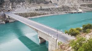
New Doda
Town
The
distance from Kisthwar to Doda town is
about 70 Km. Now actual old Doda town is completely submerged because of
Baglliar Hydral Project dam. So a
New-Doda town has been restructured and reconstructed at top of a small plateau
which is at a height. To connect Doda to Bacharach and Batote, a new solid
concrete bridge has been constructed that
crosses over Chenab River and this bridge is called a “Paka-Pul”


History
It
is said that one of the ancient Rajas of Kishtwar whose dominion extended
beyond Doda persuaded one utensil maker Deeda, a migrant from Multan (now in
Pakistan), to settle permanently in this territory and set up an utensil
factory there. Deeda is said to have settled in a village which later on came
to be known after him. With the passage of time the name Deeda has changed into
Doda, The present name of the town.
The
entire area of District Doda including Allaqa Dengbatal (Tehsil Mahore) was
initially divided into two independent States of Kishtwar and Bhaderwah. The
erstwhile Kishtwar State had been divided into eleven parganas of proper
Kishtwar, Nagseni, Padder, Marwah, Warwan, Dachhan, Kontwara, Saroor Sarthal,
Zanskar, Bawanjwah and Doda-Siraj-Banihal.
In
other words, Kishtwar State consisted of all areas of the present District Doda
including Deng Battal (Tehsil Mahore of Udhampur district) and Zanaskar of
Kargil and excluding present Bhaderwah, Bhalessa, Thathri Tehsils, Marmat
Galihan, Raggi, Assar, Batote areas of Doda and Ramban Tehsils. The history of
Kishtwar dates back to 200 B.C.
When
the revered Buddhist scholar Nagsena was invited to a discussion by king Mender
in his palace at Sakla. In the discussions Nagsena replied all the questions of
the king who then embraced Buddhism and became king Milinda.
Nagsena
recorded the discussion in "Millinda Panha" a Pali Treatise on the
fundamental principles of Buddhist philosophy.
Kahan Palor Kahan Sen was the first Raja of Kishtwar who belonged to the royal dynasty of Vikramaditya of Ujjain. He had established his rule much earlier than 1087-88 A.D. He was succeeded by Raja Gandarb Sen and subsequently by 45 others in line of succession. The territory of Kishtwar was conquered by Raja Gulab Singh in 1821. A.D. when Raja Mohd Teg Singh surrendered at Doda without any resistance.
Kishtwar was annexed to Jammu kingdom in 1821 A.D. but Gulab Singh did not visit Kishtwar. He appointed Mian Chand Singh as Amil (Administrator) of Kishtwar. One Lak Shan was appointed as kardar under Chain Singh (Neeli Akhon-wala). Chain Singh was replaced by Mehta Basti Ram as administrator of Kishtwar. Raja Gulab Singh appointed Zorawar Singh as Governor of Kishtwar in June 1823 who remained in power up to 1841. Marwah was annexed to Kishtwar during Zorawar Singh's first Ladakh expedition (1833-34). From 1934-1841 Zorawar Singh led four expeditions to Ladakh.
When Zorawar was busy in crushing rebellion in Zanskar, Ratnu the Palsara or Chief Official of Chamba Raja in Paddar, stirred up the people and seized the Dogra soldiers kept at Chaattargarh Fort in Paddar. In the spring of 1836 Zorawar Singh personally commanded a large force of about 3,000 men to avenge the insult. Chattargarh's name was changed to Gulabgarh. When Zorawar Singh conquered Paddar, Ratnu fled away to Chamba where from he was sent to Jammu as a prisoner. During the fourth invasion of Ladakh, Zorawar Singh was killed on December 12,1841 by a Tibetan soldier in the battle of Doyo.
On the death of General Zorawar Singh, Mian Jabbar Singh was sent as Governor of Kishtwar in 1842 A.D. In 1846 A.D., the whole of Jammu and Kashmir situated in the eastward of the river Indus and westward of the river Ravi including Chamba and excluding Lahul was handed over to Maharaja Gulab Singh. Thus the province of Kishtwar also formed part of the J&K State. Sometime during 1875 ADD the J&K State was divided into two division called provinces and the status of Kishtwar got reduced to a district with Ramban as its Tehsil. Lala Sarb Dayal is considered as the last Governor of Kishtwar province. Kishtwar remained as a district headquarters upto 1909 A.D. and was then placed under Udhampur Wazarat. District Doda was ultimately carved out in 1948 A.D.
The Islamic faith entered the region of Kishtwar, when Hazrat Shah Farid-ud-Din came over to Kishtwar via Dengbattel, Ramban and Doda, in 1664 A.D. When Raja Jai Singh ruling the while going to Kishtwar, he stayed at Doda for the long long 14 years and then left for Kishtwar.
The principality of Bhadarwah was distributed into 15 tharas or administrative units. The total area of Bhaderwah Jagir (including Bhalessa etc) was 533 sq.miles which after amalgamation with Udhampur district in 1931 was reduced to 213 sq.miles only. The earliest mention of the place is traced from Rajatarangni around (1112-28 A.D.), where the place has been named as Bhadravakash i.e. good resting place.
According to the genealogical role of the Rajas of Billawar, the State of Bhaderwah was found about fifteenth century by a Scion of Balauria family, but later on, came under the control of Chamba. Thus it may be presumed that the State was established any time around 12th century, but the events of the place, right up to the close of 16th century are not very clear.
Nag Pal (IInd) was the son of Maha Pal who, like his father was a great devotee of Basak Nag. He is said to have ruled for one hundred years. Mela Patt is celebrated at Bhadarwah in honour of Nag Pal's spiritual victory over Emperor Akbar. After Nagpal (IInd) the political conditions of Bhadarwah principality were very uncertain up to the 17th century. Nag pal is said to have died about 1620 A.D. Nag Pal (IInd) was succeeded by Bhakhat Pal (1620-35 A.D.) and many others. Bhadarwah became a part of Chamba State during the reign of Charat Singh, (1821-44 A.D.).
His brother Zorawar Singh was appointed its Administrative Governor. Being a man of fine tastes Zorawar Singh preferred to stay at Chamba and administration of Bhadarwah was conducted by a succession of Subedars, who could not win over the local inhabitants. Zorawar Singh was designated as Titualar Raja of Bhadarwah in 1833 A.D. and was termed as Chhota Raja.
In 1844 A.D. Sri Singh was seated on the Gaddi of Chamba. Due to family dispute, Zorawar Singh fled to Bhadarwah and then to Jammu where he tried to gain the support of Jammu and rebel elements of Bhadarwah, but he could not succeed till his death. Zorawar Singh's son, Prakaram Singh was made Raja of Bhadarwah in 1845 A.D. But owing to Anglo-Sikh war of 1845, Sikh dominion of the Hill States became very weak and Gulab Singh availed this opportunity to annex Bhadarwah with his territory. The same year when Prakaram Singh was its Raja, Bhadarwah passed on to Maharaja Gulab Singh in 1846 A.D.
During Gulab Singh's time, Bhadarwah remained a military administered area, administered by a Special Administrative Officer and it was only in the later year of Ranbir Singh's rule, that Bhadarwah was bestowed as Jagir to Amar Singh. Bhadarwah in Ranbir Singh's time remained as private Jagir. Ranbir Singh appointed Lhab Joo as Kardar (Tehsildar) of Bhadarwah in 1859 A.D. Bhadarwah remained a Jagir of Raja Sir Amar Singh during 1978-81 A.D.
On November 10,1886, as per report of Tehsildar Bhadarwah, the Jagir of Bhadarwah was handed over to the representatives of Raja Amar Singh by Tehsildar Bhadarwah and it remained his personal domain with all Powers for its administration, development and revenue collection till his death in 1911 A.D. Thus for almost all practical purposes Amar Singh was ruler of Bhadarwah between 1886 and 1911. When Amar Singh passed away in 1911. A.D. Maharaja Pratap Singh issued an order regarding the Jagir and a committee of management was constituted for the estate of Hari Singh for the disposal of civil and criminal matters.
Pratap Singh passed away in 1925. He had no issue and therefore Amar Singh's son Hari Singh occupied the throne of J&K State. The status of the Jagir was changed. Its name as private Jagir was changed to Private Domain and incharge jagir was changed to Director Private Domains. On the recommendations of Private Domain Assimilation Committee, the status of Bhadarwah ended in 1930 A.D. Consequently Bhadarwah became a tehsil of Udhampur District in 1931. After establishment of District Headquarter Doda, Bhadarwah was made a tehsil of this District.
Consequent upon reorganization of District and Tehsils, Naibat Thathri and Niabat Bhalessa of Bhadarwah Tehsil also became fully fledged Tehsils in 1981.
Chenab
River
The
waters of the Chenab start from snow melt from the Bara-Lacha Pass, in Himachal
Pradesh. The waters flowing south from the pass are known as the Chandra River
and those that flow north are called the Bhaga River. Eventually the Bhaga
flows around to the south joining the Chandra at the village of Tandi. A
motorable road runs along the Bhaga River, from Khokhsar to Tandi. The Chandra
and Bhaga meet to form the Chandrbhaga River at Tandi. It becomes the Chenab
when it joins the Marau River at Bhandera Kot, 12 km from Kishtwar Town.
It flows from the Jammu region of Jammu and Kashmir into the plains of the
Punjab, forming the boundary between the Rechna and Jech interfluves
(Doabs in Persian). It is joined by the Jhelum River at Trimmu and
then by the Ravi River at Ahnedpur Sial. It then merges with the Sutlej River
near Uch Sharif, Pakistan to form the Panjnad or the 'Five Rivers',
the fifth being the Beas River which joins the Sutlej near Ferozepur,
India. The Chenab then joins the Indus at Mithankot. The total length of
the Chenab is approximately 960 kilometres.
History
The
river was known to Indians in the Vedic period as Chandrabhaga. In
325 BC, Alexander the Great allegedly founded the town of Alexandria
on the Indus (present day Ich Sharif or Mithankot or
Chacharan in Pakistan at the confluence of the Indus and the combined stream of
Punjab rivers (currently known as the Panjnad River
The
Chenab River is also called as the “RIVER OF LOVERS” because of the . It is the
iconic river around which Punjabi consciousness revolves, and plays a prominent
part in the tale of Heera Ranjha , the Punjabi national epic and the
legend of Sohni Mahiwal.
Salal
Hyderal Project is already functional. This river has been in the
news of late due to the steps taken by the Indian government to build a
number of hydroelectric power dams along its length in India, notably Baglihar
Dam , as part of the Indus Basin Project . These planned projects on
Chenab have been contested by Pakistan, though Pakistan's objections have been
dismissed by the Indian government.
DODA
RIVER
The Doda
River or the Stod River is a river 79 kilometres
(49 mi) long, which forms the Stod Valley in the Zanskar valley of
the Ladakh region.
The
Doda River rises from the Drang-Drung Glacier near Pensi-La, mountain pass off
the Zanskar-Kargil road. The Drang-Drung Glacier is a river of ice and
snow by itself and is the largest glacier other than the Siachen Glacier in
Ladakh outside the Karakoram Range. It gives rise to a mountain peak named
"Doda Peak", 21,490 ft (6,550 meters) high, and it is the
namesake for the Doda district , which lies in the rear side of
the glacier; the Doda River is also known as Stod River. After rising from
its source, the Doda River flows southeast down along the Kargil -
Zanskar road in the main Zanskar valley, through the towns of Akshu, Abran,
Kushol and Phey. The river then passes a confluence with its
tributary, the Tsarap River, at Padum, the capital of Zanska. Together,
these two rivers form the Zanskar River, a tributary of the Indus River
The
river at Kursha Monastery
The
Doda River contributes to the minimal agricultural production of the Zanskar
valley by providing irrigation to the fields of barley, wheat, buckwheat and
peas. Accessible in the summer, the Pensi-La mountain pass at the
source of the river receives heavy snowfall along with the other pass Zojila ,
which cuts off the Stod Valley from the rest of the country during winter, and
the river freezes during this season. The river source at Pensi La lies 350
kilometres (220 mi) east from the Srinagar r, the capital of Jammu
and Kashmir. The Doda River is famous for adventure sports. Rafting
events are organised throughout the length of the Doda and the Zanskar.


.jpg)


.JPG)
.JPG)
.JPG)
.JPG)
.JPG)
.JPG)


